Author: FCLID
Levee Raising Project Nearing Completion
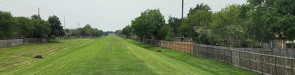
The third segment of raising the FCLID levee is nearing completion this month, October, 2023 (ahead of schedule).
The contractor has brought in the select fill material from the neighboring District’s (FBC LID 2) Ditch “B” widening project and has filled the levee to the required height. As-built surveys of the levee top have been reviewed and all levee top elevations meet or exceed the required height. The contractor will be seeding the levee and cleaning up the site for his ultimate move out. We expect full completion of the project by the end of this month.
The levee raising project was completed in three segments, with the soils coming from two FCLID pond expansion projects and the FBC LID 2 project to complete the raising of the levee segments to at least the 500-year flood level of the Brazos River.
Project Continuation
June 22, 2023
Levee Raising Near Lake “A-2”
Since the completion of the Ditch “B” and Lake “A-2”/Pond “A-3” projects in mid-2022, the District has undertaken a third project to complete the raising of the levee just south of Double Lakes Dr.
The former projects did not produce enough excavated material to raise the entire levee. This third project is in concert with an excavation project within FBC LID 2 and the District is using that material to raise the remaining portion of the levee. Construction traffic will be accessing the site using the Double Lake driveway near the Heritage Colony Clubhouse.
The project began in late May and is expected to be completed by December, 2023.
Future Project Update
June 22, 2023
Joint Pump Station with LID 19
The District is participating with LID 19 and MUD 115 (Riverstone districts) in the construction of a second pump station along Steepbank Creek which will provide approximately 200,000 gpm additional pumping capacity for extreme rainfall events coincident with high Brazos River events outfalling into the Flat Bank Creek Diversion Channel. The District undertook this joint project in lieu of adding a pump station inside of the District near the Lake “A-2” outfall into Steepbank Creek since an internal pump station would have necessitated pumping that water a second time from the LID 19 downstream system.
The project has recently received its environmental clearance from the Texas Water Development Board (TWDB). The final electrical controls design is currently underway. The project is expected to go into the bidding phase in late 2023 with construction expected to begin in early 2024. The estimated construction time is 12-15 months.
Why Do I Pay LID Taxes?
All FCLID property owners pay property taxes that provide for the maintenance, upkeep and debt service of the levee. The construction of the levee was funded through the issuance of tax exempt bonds.
FCLID Addresses New NFIP Flood Insurance RR 2.0
First Colony LID has joined the Fort Bend Economic Development Council (FBEDC) with other levee districts in the County to form the FBFMC (Fort Bend Flood Management Committee).
The purpose of this coalition is to come together to form a strong, collective voice to address federal, state, and local regulations and guidelines that affect leveed areas. You can follow this committee on the FBEDC here.
The FBFMC has engaged consultants to work with the member districts to identify the issues and formulate legislative relief so we continue to benefit from the many years of successful flood management here in FBC.
In 2021, the Federal Emergency Management Agency (FEMA) changed how flood insurance (National Flood Insurance Program, NFIP) rates are calculated for your home and property. A new rating system called Risk Rating 2.0 (RR 2.0) was introduced. RR 2.0 supposably allows FEMA to determine premium rates per property based on factors such as proximity to a flooding source, 1st floor elevation, replacement cost of rebuilding, etc. This is not a complete list because FEMA has not disclosed exactly how the rate engine is formulated.
In the past, premium rates were determined by mapped flood zones. In the 100-year floodplain (aka, special flood hazard area or SFHA) federally-backed or regulated lenders must require that flood insurance be purchased and maintained. Leveed districts in Ft. Bend County are accredited by FEMA, thus avoiding the SFHA designation. As a result, homeowners received Preferred Rate Policies, saving hundreds of dollars, and were exempt from this mandatory purchase of flood insurance.
Under the new NFIP RR 2.0, flood insurance has become a major concern as premium rates have increased, policy holder numbers across the country have started to decrease, and new guidelines are being implemented that potentially could have a negative effect on us and other levee districts.
Some of the current steps being taken by the EDC and FBFMC to address this concern are:
- Setting the goal of: Affordable, voluntary flood insurance for 100-year accredited levee protected areas,
- Requesting that accredited levees continue to exempt protected communities from SFHA designation and mandatory flood insurance purchase,
- Requiring FEMA to be transparent with the RR 2.0 methodologies and disclose the full actuarial premium on all NFIP flood insurance bills,
- Ensuring the data being used by FEMA to set RR 2.0 rates in leveed areas is correct.
Through our participation in the FBFMC under the EDC, this district will continue to monitor and challenge any change that goes against the best interest of our residents and businesses.
We trust you will stay engaged and support our efforts through this coalition on your behalf.